Rock Routes at Green's Cliff: grouped by Area, sorted by Name
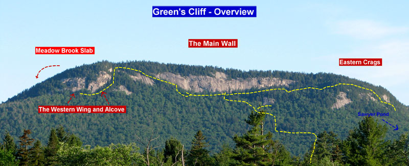
Description: Green's Cliff is a collection of granite crags overlooking (especially the NE Crags) the scenic Sawyer Pond basin. Long considered a semi-outback crag, the new way in from the north has considerably reduced approach times and no longer requires mountain bikes. From closest to furthest with approximate approach times are: The North East Crags 30-60min, The Main Wall 1-1 1/4 hr, The West Wing and Alcove 1 1/2 hr, and furthest west on the same formation are the Meadow Brook Slabs (best approached from the Kanc.)
THE AREAS: The Northeast Crags is a very featured band of rock broken into tiers, sometimes with wooded ledges and setback upper walls so there is much more climbable rock than may at first appear from the base. Alternative approaches to some of the upper pitches may include a scramble up to and traverse of a tree ledge and then 40' tunnel through the cliff to pop out at a second pitch belay! Routes can be as much as 4 pitches long broken by ledges, but most are long half rope pitches. This is a great area for the Summer when you might get baked off the Main Wall, as it faces more east so gets morning sun and afternoon shade
The first developed area you come to after taking the left split of the approach trail, dropping down and traversing under the ridge line, is the Bigfoot area, notable for some great cracks in the 5.9-11 range and the namesake 12a/b arete.
Just a minute or two past the Bigfoot arete you come to a landmark basalt gully sometimes referred to as 'the Big Green Gully'. It is about 40 ' across and runs the full high of the cliff band, steepening up to overhanging at the top. Take care when crossing it and don't climb above others as the scree is very sharp and loose
Staying low and traversing across the mouth of the gully leads you in a few hundred feet to The Premarital Wall, a 100 foot just under vertical wall which currently only has one route (a 5.11 that needs recleaning) but potential for more technical thin seam and face climbs. Unfortunately this is one of the wetter walls so suffers from seepage much of the time.
Angling up the scree gully a little instead and escaping out it's left side to follow a trail above the Premarital Wall brings you in another minute or two to the Beanstalk Wall, bringing you to about its center, with the two pitch chimney crack Squeeze Box 5.8+ above. Currently (2016) there are about ½ dozen established crack lines here and to the left in the 5.9-10 range including the namesake Beanstalk Crack 5.9 and a couple projects off to the right.
Following along to the left end of the Beanstalk Wall, a climber's trail will continue angling up and left a little bit to a somewhat chossy steep buttress (one established line, Encour du Bottom Feeder 5.9-) Just to the left of the obvious crack of EDBF is a short slot you can scramble up. If you continue up the hill a few minutes you will run into the upper approach trail. Left takes you to the Main Wall in about 5 minutes, right takes you back down along the ridge above the NE Crags to the approach junction )15 min), Sawyer Pond Tr (another 15 min) then the car.
The Main Wall is the prominent white cliff band you can see from the Kanc. looking NW across the bog near Passaconaway. It is about 1/3 of a mile long and approximately 250' tall at the center. Most of the routes here tend to be a couple pitches long with some potential for a third and follow prominent features like the big flake system of Green Party or classic 2 pitch crack of Greenpeace separated by seemingly blank sections in between. Considering the size of the cliff, the number of establishes routes here is still pretty low, but there is a good range, from 5.7 to 13 and the quality is mostly high. It pays to have good slab skills as well as jamming as there are some excellent slab pitches here along with the cracks. Some of the amazing looking potential steep second pitch projects are guarded by the very difficult slabs of the porcelain wall section. For the most part routes are pretty well protected (occasionally a little spicy) and have bolted anchors making getting down easy with one rope, but there are a few notable exceptions.
For getting to the Main Wall it is most direct to take the right branch of the climber's trail that continues up the ridge from the junction with the cairn with prayer flags wrapped around it about 30-40 minutes in. About 5 minutes before the Main Wall and just after the trail has topped out you will see a trail coming up the hill from the left (from the left side of the NE Crags) Pass this and the trail will continue, arcing a little right on a small plateau then dropping down through some boulders and up to the base of the right side of the cliff.
The Western Wing/The Alcove To the left of the Main Wall, past 2 small slabs stacked on top of each others, is an east facing steep section of cliff approximately 200 feet tall, that angles down the hill. This area is notable for the featured yellow alcove where an amazing overhanging and arching crack is found (aided as '357', freed at 13b and called 'Angel' ). Around the toe, to the left, the Western Wing continues as a large area of mostly undeveloped rock that is probably hiding a few gems.
There are a number of dramatic and steep lines at the Alcove including roof cracks . Unfortunately the area suffers from mixed quality rock, from great to patches of horrible, so head up with care. Some of the old routes that were originally aided currently (2016) are in rough shape and need their hardware replaced (including 357) Check for updated information and don't trust the anchors blindly. Many of these lines look well worth some TLC and will hopefully get some soon.
The Alcove faces more easterly than the Main Wall and gets some cooling shade from the tall conifers and there are some cool boulders below so it is a place to check out while taking a break from the midday heat of the Main Wall.
To approach the Alcove first get yourself to the Main Wall. Taking the high trail along the ridge above the NE Crags will save you 10-15 min and some up and down. Once at the Main Wall, head left, past the great Arch and near the base of the route House Made of Dawn look for a cairn and trail leading out from the cliff. Almost immediately it splits. Take the left branch (right goes up to the left side of the Main Wall) traversing the hill, angling up between two intervening slabs to reach the upper end of the Alcove. It is about a 10 minute hike from the Main Wall.
Directions: From 302 drive south about 4 miles on the dirt Sawyer River Rd all the way to the last gate Park in the large clearing on the right. (From Bartlett Sawyer River Rd is west and just past the Fourth Iron Bridge, on your left) Continue on up the road on foot, past the gate and kiosk a few hundred feet and take a left onto Sawyer Pond Trail, immediately crossing the river via the footbridge. Continue along the trail like you were going to the pond and in about 5 minutes you come to a second, smaller bridge (the boardwalk right after the first doesn't count). Leave the trail just before crossing this second bridge, cutting right into the woods, initially staying near the bank of the stream for maybe 50+ ft, then bearing away from it a little (heading directly south) to follow a shallow, somewhat nebulous drainage a couple hundred feet. Move to the left side of it, passing by two huge yellow birches that almost cross each other. It is important to be careful to not beat in the start of the trail here or mark it. A fair number of yahoos head into the pond and there is no sense in drawing them up to the crags to leave their poop and beer cans. Once you are familiar with the area try to go in and out a slightly different way off the Pond Trail and tread lightly.
Once you are in a couple hundred feet, around N44.05243 W71.39998, find the flagging and the way should be easy to follow, You are pretty much heading directly south and then bending more SSE, up the shoulder of the wooded ridge. Along the way you will cross two overgrown skidder trails, making very short jogs on them to the left before resuming up the hill. Once up on the ridge you continue along it heading south, with some great views through the trees out over the very scenic Sawyer Pond basin, with cliffs all around. At around N44.04330 W71.39683 you will get to a junction marked by small boulder with the roots of a large yellow birch tree growing over it, with a cairn on top (possible prayer flags wrapped around the cairn).
At the junction bear left for the Northeastern Crags, over a small rise then down a shallow coll and then turn right, now traversing below the gradually growing cliff line that eventually becomes the Bigfoot area marked by the obvious sharp arete. It is about an hour from the car to Bigfoot, 40 min if you hike fast.
For the Main Wall, if you want to skip the NE crags and get there directly, at the prayer flag junction bear right and generally continue snaking uphill along the ridge line above the Northeastern Crags. See the Main Wall description for further directions.
If you are stopping by the NE Crags first, from there you can take the trail from the left side of the Beanstalk Wall and through the Bottom Feeder notch to meet up with the ridge trail and take a left to the Main Wall, it probably adds an extra 10+ minutes of hiking and a little more up and down.
For more updated info check MountainProject.com and search the forum here, especially the new route section.
Note: Sawyer Pond Rd is seasonally gated at 302 usually from some time in Nov to May.
Climbing is a very dangerous sport. You can get hurt or even kill yourself. When you go climbing, you do so of your own free will. Everything on this site is to be taken with a grain of salt. Don't blame us if you get up some totally heinous route, in over your head and fall and hurt yourself.